Tanzania Food Security Monitor
2017
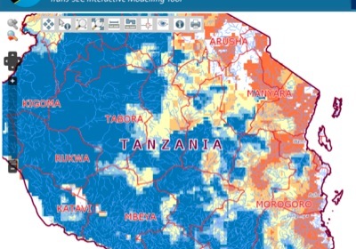
delivers in a dekadal rhythm information on the potential biomass productivity all over Tanzania. The algorithm behind the monitor is the „Water Requirement Satisfaction Index“ (WRSI, FAO). Based on regularly updated NOAA data on rainfall and potential evapotranspiration (PET) the WRSI is calculated for 12km by 12km tiles and presented as six categorical food security indicator classes. Recent and historical dekadal spatial pattern can be downloaded.
The Tanzania Food Security Monitor
Documentation
Description of the Map Viewer (PDF)
Metadata document for GIS layers and other data used throughout the tools and maps
Documentation