Tanzania Food and Land Productivity Information System
2017
provided by Trans-SEC
This Web-GIS project was funded by the German Federal Ministry of Education and Research and realized in the framework of the Trans-SEC project (2013-2017, http://project2.zalf.de/trans-sec/public/) by a cooperation between Sokoine University of Agriculture (SUA), Morogoro, Tanzania and University of Hohenheim (UH), Stuttgart, Germany under support of Potsdam Institute for Climate Impact Research (PIK).
This information system has been created in order to speed up exchange of data and information in and about Tanzania. This way it is thought to enable faster development particularly in the agricultural sector.
The ”Tanzania Food and Land Productivity Information System“ consists of four major components:
-
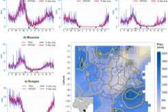
1.The ”Tanzania Food Security Monitor“
-
2.The ”Land Evaluation Tool“
-
3.The ”Map Viewer“
-
4.The ”Natural Resource Data“
Additionally, information and documents related to the Trans-SEC project and the above mentioned components are provided.
This whole information system is open source-based.
Please explore its functionality and contribute with your wisdom to knowledge generation in Tanzania!
General Info
The map viewer provides static maps on natural resources and other topics from freely available sources.
Use the land evaluation tool for your own purposes! It is particularly suited for ex-ante identification of project intervention areas.
The Tanzania food security monitor provides information on the potential biomass productivity and is updated every ten days.

From the natural resource data you can downlad data and statistics on crops, climate, land and soil for various purposes including modeling.